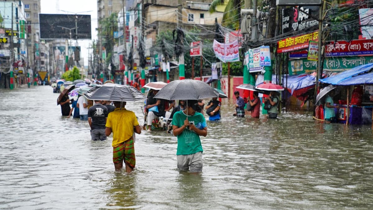
Nearly three million people have been stranded and at least two lives have been lost due to floods in Bangladesh, which have submerged vast regions.

Also Read: Eruption of Russia’s Shiveluch Volcano Follows 7.0-Magnitude Earthquake
Numerous residents have been forced to evacuate their homes, utilizing boats and other methods as the floodwaters breached residential areas.
Video footage shows people wading through knee-deep water, carrying their belongings in a desperate attempt to seek shelter.
The worst-hit areas include Feni, Moulvibazar, Habiganj, Comilla and Chittagong. These districts are facing the flooding with five major rivers reported to be flowing above the danger levels.
The Flood Forecasting and Warning Centre has issued warnings that with continuous rainfall and water levels are expected to rise further over the next 24 hours.
The floods has affected road connectivity in multiple regions.
A 2015 analysis by the World Bank Institute estimated that 3.5 million people in the country are at risk of annual river flooding.
India’s Ministry of External Affairs issued a statement clarifying that the floods in the country were not caused by the release of waters from the Dumbur dam on the Gumti River in Tripura.
The ministry addressed that the flooding in Bangladesh is due to heavy rainfall in the catchment areas downstream of the dam.
The Dumbur dam is located over 120 kilometers from the Bangladesh border and it is a low-height dam. It generates power that feeds into a grid from which Bangladesh also draws 40 MW.
India has water level observation sites along the river course and it has been transmitting real-time flood data to the neighboring country as per bilateral protocols.
In India’s Tripura state, which has also been affected by the same weather system, 12 people have died due to landslides and floods.
The Indian government has deployed disaster management teams, boats and helicopters to assist in rescue operations.
The Indian ministry’s statement underlined the need for close cooperation between India and Bangladesh in managing shared rivers which often cause flooding on both sides of the border.
The Gumti River is a trans-boundary river that originates in the northeastern Indian state of Tripura and flows into Bangladesh.
The river passes through the Chittagong division in Bangladesh affecting areas like Comilla before joining the Meghna River.
Also Read: World’s Oldest First-Time Panda Mom Ying Ying Gives Birth to Twin Cubs
The MEA has denied that the floods in Bangladesh were caused by the release of water from the Dumbur Dam. The ministry addressed that the dam is located over 120 kilometers upstream from the Indo-Bangla border.
The Dumbur Dam is described as a low-height structure, approximately 30 meters tall primarily used for power generation. The country also receives 40 MW of power from this dam.
According to the India Meteorological Department, the heavy rains responsible for the flooding were due to a low-pressure area over central Bangladesh and the adjoining region.
The Gumti River’s catchment areas both in India and Bangladesh experienced the heaviest rainfall of the year during the period leading up to the floods.
The MEA pointed out that heavy rainfall had been occurring since August 21 in Tripura and adjacent districts in the country.
Tripura has been affected by the floods with more than 34,000 people displaced. Reports from Tripura indicate that at least nine people including three members of a single family have died due to landslides and drowning incidents.
Rivers in Tripura, the Gumti are flowing above critical levels with the main river crossing the extreme danger level. The Indian government has deployed National Disaster Relief Force teams to the region.
India and Bangladesh share 54 cross-border rivers. The MEA underlined the importance of continued cooperation between the two nations to address the challenges by such natural disasters.
There are three water-level observation sites along the Gumti River in Tripura, Amarpur, Sonamura and Sonamura 2, which are part of a bilateral protocol for real-time data sharing with the country.
Data showing rising water levels were transmitted to Bangladesh up to 3:00 PM on August 21, 2024 in accordance with the bilateral protocol.
However the floods caused a power outage at 6:00 PM, which disrupted communication channels. Efforts were made to maintain contact through alternative means designed for urgent data transmission.
The floods have affected eight districts including Sunamganj, Maulvibazar, Habiganj, Feni, Chittagong, Noakhali, Comilla and Khagrachari. Deaths have been reported in these regions due to the floods.
The IMD has issued warnings of heavy rainfall in the northeastern regions of India including Assam, Meghalaya and Tripura due to the low-pressure system persisting over north Bangladesh.
The rainfall in South Tripura has been heavy with Bagafa recording 49 centimeters within 24 hours from 8:30 AM on August 21 to 8:30 AM on August 22.
The IMD also predicts the formation of a cyclonic circulation over the North Bay of Bengal and neighboring areas around August 24.
Also Read: Bananas: Fusarium Wilt is Pushing Our Favorite Fruit Toward Extinction